
Jay-Jay & Flynny had a chat with Chris Brandalino from the ‘National Institute of Water and Atmospheric Research’ (NIWA) about what to expect from Cyclone Gabriel that’s very likely to hit the North Island on the weekend. And Chris thinks things could get pretty bad, so get prepared for the worst.
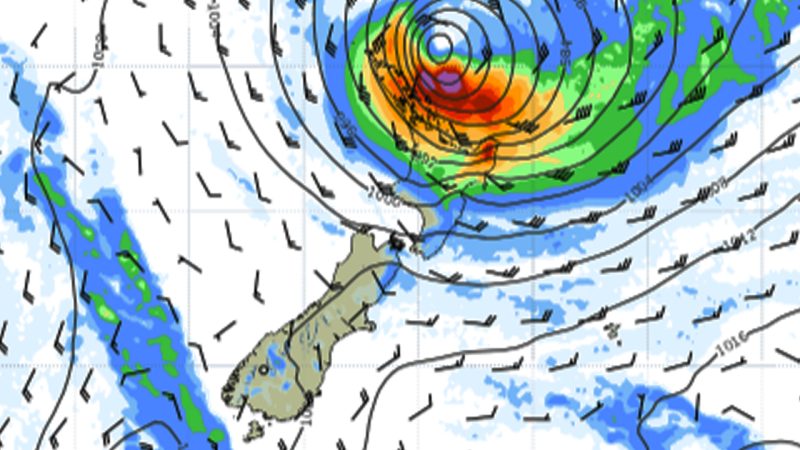
“We’re looking at some major impacts for the upper North Island,” he said. “It’s gonna be the whole North Island but in terms of where the worst weather could be, right now it looks like the upper half - draw a line from Gisborne, Taranaki northbound, roughly.”
“ We wanna be proactive and not reactive,” Chris explains. “You wanna be prepared so if you do have to take action because things are just too gnarly you’re able to do so quite quickly.”
“Think about the plan now so if you have to execute the plan it’s ready to go.”
He said that although there is a slight possibility the cyclone changes course and the impacts are not super bad, “the odds of something quite significant happening are increasing.”
He warns that Saturday night is when the heavy winds will begin, (Ed Sheeran in Auckland should be good to go “weather-wise” but there might be “other forces that impact that decision”) but Monday and Tuesday will see the worst of it AKA “when the proverbial hits the fan”. Chris breaks ‘the proverbial’ down further, by the elements.
RAIN
“We’re thinking around 100 - 150ml of rain, some are saying 100 - 200ml,” he explains. “To put that in perspective places like Auckland and Whangarei typically get about 75 - 90ml of rain in the entire month of February.”
“The amount of rain that is likely to fall in a day or two is likely to be equal, maybe even double, what would typically occur for the whole month… the ground as we all know is absolutely soaking wet so the ability for the ground to absorb that is compromised. So flooding is a risk,” he added.
WIND
“The wind is going to be quite strong,” Chris warns. “Potentially an extended period - a day or two - of very strong winds where it really increases the odds of power outages and wind damage.”
He advises you to plan now, so you can execute quickly if things do go bad. You might have no power for a couple of days so stock up on batteries, torches, and whatever else you need. Also note if you are a flood risk and if so, if it’s worth it to go somewhere else now.
STORM SURGE
Storm Surge is “water coming to where it shouldn’t be (land)”, Chris says. “ With all this strong wind and very low air pressure that tends to elevate the water in very big waves of course there’s going to be some pretty significant storm surge on either side of the coast, but right now it’s favouring … the Bay of Plenty, the Coromandel, up through the Auckland and Northland region.”


